



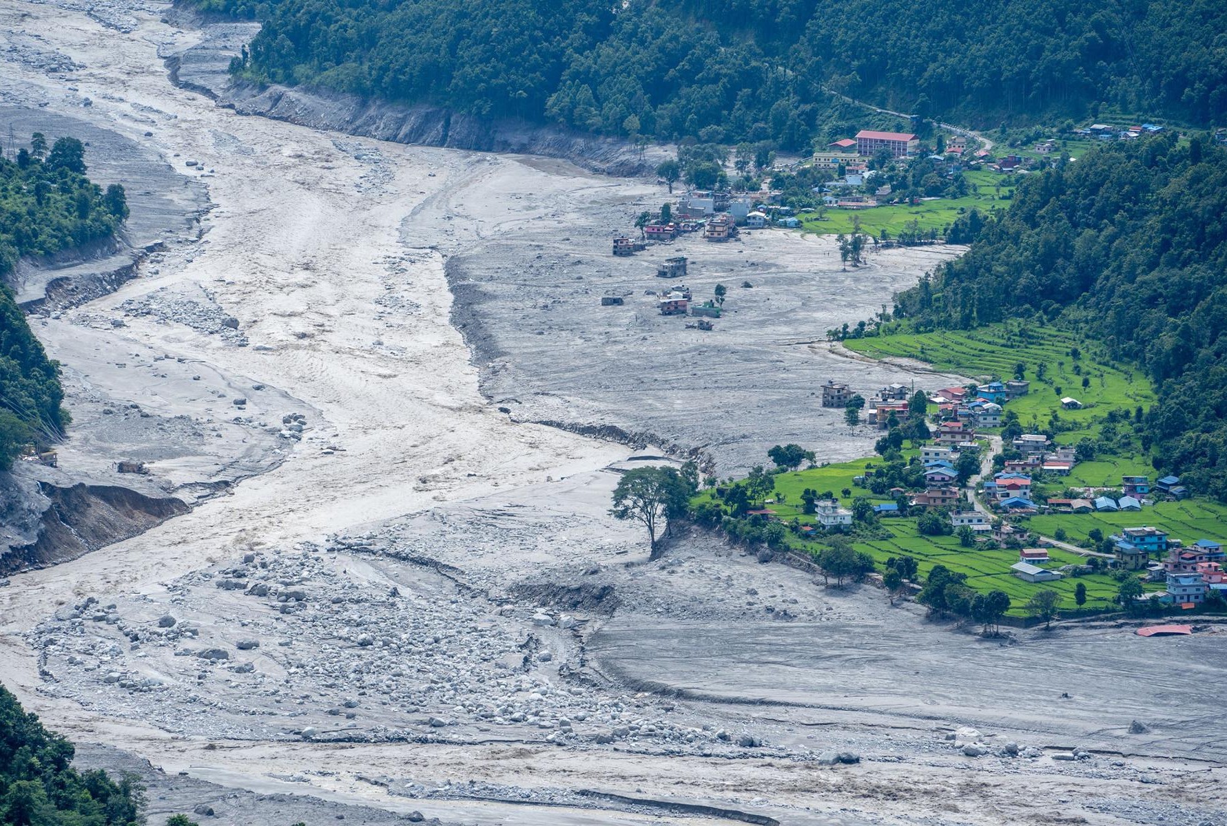
KATHMANDU: On the morning of August 26, the Bhote Koshi river in Rasuwa suddenly surged.
Until moments earlier, the river had been flowing normally. Then came a powerful torrent carrying ice, rocks, mud and debris. The surge travelled through Rasuwagadhi, Timure and Syabrubesi before reaching the Trishuli river, damaging settlements, roads, bridges and hydropower infrastructure along the way.
For communities accustomed to living beside a mountain river, flooding was not unfamiliar. But this was not a conventional flood.
A preliminary assessment by the International Centre for Integrated Mountain Development (ICIMOD) suggests that a large mass of ice and rocky debris may have fallen into the Lhende Khola, a tributary of the Bhote Koshi. The debris may have blocked a narrow section of the river, creating a temporary lake before the accumulated water and debris suddenly surged downstream. The precise sequence of events, however, remains subject to further investigation.
The National Disaster Risk Reduction and Management Authority gave a broadly similar preliminary account. At about 8:40am, it said, an ice-rock avalanche occurred in the upper catchment near the Nepal-China border. The resulting flow of water and debris entered the Lhende Khola before reaching the Bhote Koshi.
In simple terms, the preliminary picture is this: ice and rock fell, the stream was blocked, water and debris accumulated, and the obstruction either failed or was overtopped, unleashing a sudden flood.
That sequence matters because it broadens the definition of what constitutes a Himalayan flood risk.
A different trigger, a familiar warning
The event inevitably recalls Langtang 11 years ago.
After the earthquake of April 25, 2015, a massive avalanche swept down the southern face of Langtang Lirung. A mixture of ice, snow and rock devastated Langtang village. The earthquake was regarded as the principal trigger.
The latest event appears to have followed a different chain of events. Preliminary assessments indicate that ice and rock fell from the northern sector of Langtang Lirung, affecting the Lhende Khola.
In 2015, an earthquake triggered an avalanche. This time, an ice-rock avalanche appears to have blocked a river and generated a sudden flood. Yet the two disasters point towards the same underlying concern: the instability of high-mountain terrain.
“Large quantities of rock and ice appear to have fallen from the high Himalayan region and moved rapidly downslope,” says Sunvi Maskey, an ice and climate researcher at ICIMOD. “They may have temporarily blocked the stream, allowing water and debris to accumulate. When the blockage failed or was overtopped, a sudden flood carrying debris appears to have occurred.”
The episode, she argues, should be understood as a cascading hazard—a disaster in which one event creates the conditions for another.
That is increasingly important in the Himalayas. The danger is no longer confined to a glacier lake bursting its banks. A landslide of ice and rock can block a river, create a temporary lake and then release a destructive surge without a conventional glacial lake outburst flood ever occurring.
The fear of glacial lakes
Glacial lakes remain one of the region’s most important hazards.
A joint study by ICIMOD and the United Nations Development Programme identified 3,624 glacial lakes across Nepal, Tibet and India. Of these, 2,070 are in Nepal, 1,509 in Tibet and 45 in India.
Not every glacial lake is dangerous. The study identified 47 as potentially hazardous: 21 in Nepal, 25 in Tibet and one in India. Forty-two of those potentially dangerous lakes lie within the Koshi basin.
The study classified 31 of them in the highest-risk category. It concluded that regular monitoring, risk assessment and early-warning systems are essential to reducing the danger.
The geography makes the problem more complicated for Nepal. Of the potentially dangerous glacial lakes in the Koshi basin, 22 are in Tibet and 18 are in Nepal. A hazardous event on the Tibetan side can therefore have consequences far downstream in Nepal.
The assessment was not based simply on counting lakes. Researchers considered the condition of the lake, the stability of its retaining dam, the associated glacier and the surrounding terrain when identifying potentially dangerous lakes.
The implication is significant: Nepal’s exposure is not determined solely by what happens inside its borders.
A lake forming or becoming unstable in the high mountains across the border can affect Nepal’s river systems. So can a sudden flow of water, ice and debris originating in unstable mountain terrain.
That is precisely what made the recent Bhote Koshi flood so unsettling. Residents in parts of Rasuwa, Nuwakot and Dhading were reportedly reluctant to believe flood warnings because there had been little or no rainfall locally.
The episode has challenged an old assumption that sudden Himalayan floods necessarily begin with a glacial lake.
They do not.
A large mass of ice and rock falling into a river can itself create a temporary blockage. Water accumulates behind it. When the barrier fails, the resulting surge can carry enormous quantities of sediment and debris downstream.
That appears to be one possible explanation for what happened in the Bhote Koshi.
The hazards beyond the lake
Nor is the phenomenon entirely new to Nepal.
Researchers point to similarities with the 2003 Madi flood and the 2012 Seti flood, in which avalanches or landslides in snow- and ice-covered terrain were followed by large flows of water and debris.
The lesson is that Himalayan disaster planning can no longer be organised around glacial lakes alone.
Glaciers, ice-rock avalanches, unstable rock slopes, permafrost and potential river blockages all belong in the same risk assessment.
Climate change makes the picture more complicated, although scientists caution against attributing any single disaster to climate change without further evidence.
As temperatures rise, glaciers retreat, frozen ground can warm or thaw, and the stability of snow and ice can change.
“When water enters cracks in rock, high-altitude slopes can become more unstable than they were before,” says Maskey. “But it would be premature to say that this particular Bhote Koshi event was caused solely by climate change.”
Establishing such a link, she says, would require further analysis of temperature, rainfall, snowmelt, rock conditions, frozen ground and glacier dynamics.
That caution is important. Climate change is altering the physical environment of the Himalayas, but a specific avalanche or flood can have multiple causes—geology, topography, rainfall, earthquakes, snow and ice conditions and long-term warming among them.
A mountain range already in motion
The Himalayan hazard is not new.
The Himalayas are among the world’s youngest and most geologically active mountain systems. Rivers continuously cut into the terrain. Slopes erode. Rock fractures. Glaciers advance and retreat. The landscape is constantly being reshaped.
Climate change adds another layer of pressure.
ICIMOD research shows that glaciers have been retreating and shrinking since the 20th century, increasing the possibility of new glacial lakes forming and existing lakes expanding. That, in turn, can increase the threat of glacial lake outburst floods.

But warming can affect the mountains in other ways.
Rain falling on terrain that once received snow can penetrate cracks in rock. Water entering frozen ground can weaken permafrost. The combination can increase the likelihood of rockfalls and ice-rock avalanches.
Geologist Shreekamal Dwivedi says the upward movement of the snowline is one visible manifestation of a changing mountain environment.
“The snowline is moving higher, and the mountains are undergoing significant changes,” he says. “Mountain movement is natural, but climate change is accelerating the process. It is increasing rock deterioration and the occurrence of ice-rock avalanches.”
The distinction matters. Climate change does not create Himalayan instability from nothing. It can amplify processes that are already part of the mountain system.
“Climate change is not simply raising the temperature of the planet,” says Maskey. “It is also changing the stability of high-mountain terrain.”
Yet one disaster should not be used to declare the entire Himalayan range unstable.
The more immediate lesson is practical: risk assessments need to become broader.
“Glacial lakes are not the only hazard,” Maskey says. “Ice-rock avalanches, thawing frozen ground, river blockages and the sudden floods that follow them must also be taken seriously.”
As glaciers retreat, the loss of ice that once supported or buttressed rocky slopes may also contribute to longer-term slope instability in some locations.
From prediction to preparation
The growing range of hazards makes monitoring more difficult—and more urgent.
Nepal needs to move beyond monitoring individual glacial lakes towards a multi-hazard system covering unstable glaciers, slopes vulnerable to ice-rock avalanches, permafrost and narrow valleys where rivers can be blocked.
“Satellite imagery, cameras, weather stations, ground movement, seismic signals and river-level measurements should be integrated as far as possible in high-priority locations,” says Maskey. “Once a threat is detected, information must reach local governments, security agencies, hydropower projects and communities within minutes.”
That last point may be more important than predicting every disaster hours in advance.
Mountain disasters do not always provide long warning periods. A landslide can happen suddenly. A temporary blockage can fail within minutes. A debris flow can travel downstream faster than conventional administrative systems can respond.
Environmental scientist Dr Rohini Devkota argues that Nepal therefore needs to rethink the meaning of an early-warning system.

“As the nature of disasters changes with climate change, it may not always be possible to forecast them hours in advance,” Devkota says. “Nepal should develop a multi-hazard early-warning system capable of initiating information, decision-making and response within five minutes.”
That is an ambitious standard. But in a landscape where minutes can separate warning from catastrophe, it may be the right one.
The border does not stop a river
There is another complication: Himalayan rivers do not respect political boundaries.
Many of Nepal’s major rivers originate beyond its borders or receive flows from transboundary mountain systems. A hazard developing in Tibet can therefore become a disaster in Nepal.
Experts say Nepal and China need mechanisms for rapid exchange of information on high-altitude hazards, particularly where a sudden change upstream could threaten downstream communities and infrastructure.
Such cooperation is not simply a matter of diplomacy. It is part of disaster management.
A warning about an unstable lake, an ice-rock avalanche or a blocked river is useful only if it reaches those downstream quickly enough to act.
For Nepal, that means linking scientific monitoring with local government, security agencies, hydropower operators and communities rather than treating them as separate systems.
Chho Rolpa offers a precedent
Nepal has already demonstrated that some Himalayan risks can be reduced when they are identified early.
Chho Rolpa is one of the country’s clearest examples.
The glacial lake had expanded as surrounding ice melted, raising concern that a breach could send a destructive flood into downstream settlements and infrastructure. In 2009, the lake’s water level was deliberately lowered by about three metres through an artificial drainage system.
The intervention reduced the volume of water held behind the natural dam and therefore lowered the potential impact of a glacial lake outburst flood.
It was not a perfect solution to every Himalayan hazard. But it demonstrated the value of identifying a risk before it becomes a disaster.
That principle now needs to be extended beyond glacial lakes.
“If we fail to manage disasters, Nepal will remain trapped in this cycle,” says geologist Dwivedi. “Himalayan disasters are not over. We cannot move forward without managing them.”
He points to Japan as an example of a country that has learned to incorporate disaster management into its development model.
The comparison is revealing. Disaster management is often treated as a cost: money spent on monitoring stations, warning systems, evacuation plans and resilient infrastructure. But in a country as exposed as Nepal, it is better understood as an investment in development itself.
A hydropower plant protected from a sudden debris flow, a bridge designed for a changing river regime, a settlement warned before a flood arrives and a community trained to evacuate are not merely disaster-prevention measures. They are safeguards for economic growth.
The new Himalayan risk map
The Bhote Koshi event therefore deserves to be viewed as more than an isolated flood.
Eleven years after an earthquake-triggered avalanche devastated Langtang, a different chain of mountain processes has again turned the same broad landscape into a source of danger.
The difference is instructive.
The old mental model was relatively simple: earthquakes cause landslides; heavy rain causes floods; melting glaciers create dangerous lakes.
The emerging reality is more interconnected.
Warming can alter glaciers. Glacier retreat can change slopes. Water can penetrate rock. Frozen ground can thaw. Ice and rock can collapse into rivers. Rivers can become temporarily blocked. Temporary lakes can form. Their sudden failure can produce floods carrying enormous quantities of sediment and debris.
One hazard can become the trigger for another.
That is why Nepal’s disaster strategy must evolve from hazard-specific planning towards a system that sees the mountain as a connected physical system.
The objective is not to predict every rockfall or avalanche. That may be impossible. The objective is to identify where the consequences could be catastrophic, monitor those locations continuously, communicate across borders and institutions, and ensure that warnings translate into action within minutes.
The Himalayas have always moved.
The question for Nepal is whether its systems can move fast enough with them.