

KATHMANDU: The catastrophic August 26 flood was not an ordinary river disaster. It began high above the valleys, when a massive section of glacier and mountain collapsed on the northern face of Langtang Lirung. Within minutes, ice, rock, debris and water were transformed into a devastating flood that swept through the Bhote Koshi and Trishuli corridors.
On a normal August morning, the rivers of northern Nepal were doing what Himalayan rivers have done for centuries: carrying monsoon water down steep valleys towards the plains.
Then the mountain moved.
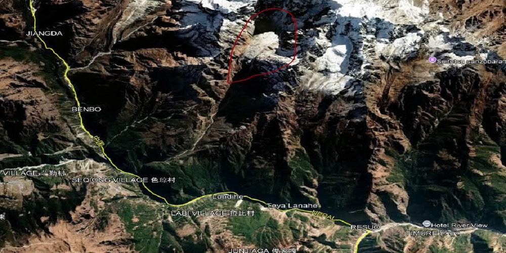
On August 26, a massive collapse occurred on the northern side of Langtang Lirung, one of Nepal’s highest mountains. A large mass of glacier and rock broke away and plunged into the high-altitude valley below, generating an enormous ice-and-rock avalanche. The material entered the Lhende Khola and rapidly transformed into a debris-laden flood that raced downstream into the Bhote Koshi and then the Trishuli river system.
What followed was not simply a flood. It was a cascading mountain disaster—ice, rock, mud and water moving together with extraordinary force.
Satellite imagery, seismic data and subsequent scientific analysis have helped reconstruct the sequence. The US Geological Survey has identified the source as a glaciated mountain cliff on the north side of Langtang Lirung and said the collapse generated energy equivalent to a magnitude 5.2 earthquake. (USGS)
The scale and speed of the event overwhelmed communities, infrastructure and even parts of Nepal’s flood-monitoring system.
From a collapsing glacier to a flood corridor
The disaster began far above the settlements that would eventually be destroyed.
Scientists studying satellite imagery and drone photographs have traced the source towards the northern side of Langtang Lirung. An enormous mass of ice and rock detached from the mountain and crashed into the valley.
The impact created a rapidly moving mixture of ice, rock and sediment. As it travelled down the Lhende Khola, it gathered more material and water, becoming a powerful debris flow before entering the Bhote Koshi.
The river system then became the highway for destruction.
The surge moved downstream through the narrow Himalayan valleys, striking settlements and infrastructure before entering the Trishuli corridor. Scientific assessments indicate that the event travelled nearly 100 kilometres, affecting areas on both sides of the Nepal-China border. (USGS)
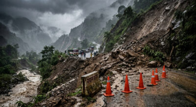
In places, the flood behaved less like a conventional river and more like a moving wall of debris.
Timure, near the Nepal-China border, was among the first settlements hit. The Rasuwagadhi border area suffered extensive destruction. Further downstream, Syabrubesi, Mailung, Betrawati and settlements along the Trishuli corridor were struck by the flood and debris.
By the time the water reached the lower valleys, the original distinction between glacier collapse, landslide, debris flow and flood had effectively disappeared.
It had become one disaster system.
Two million cubic metres of water
The immediate destruction was only one part of the danger.
According to Nepal’s hydrological authorities and flood experts, an enormous volume of water travelled through the river system on the day of the disaster. Estimates put the amount reaching as far as the Devghat area at around 20 million cubic metres, after accounting for the characteristics and density of the flow.
But the danger did not end when the first flood wave passed.
The collapse and subsequent blockage of the river system created lakes in the upper reaches. Satellite analysis has identified at least two newly formed water bodies, including one along the Lhende Khola and another below the collapsed glacier. One of the newly formed lakes has been estimated at roughly 770 metres along its major axis. (ArcGIS StoryMaps)
That has created a second and potentially more difficult problem: water accumulating behind unstable natural barriers.
If such a barrier fails suddenly, another destructive surge could move downstream with little warning.
This is why authorities have continued to monitor the Bhote Koshi and Trishuli systems even after the initial catastrophe.
The river gauges were swept away
One of the most troubling aspects of the disaster was the damage to the very systems designed to measure such events.
The flood swept away five hydrological monitoring stations operated by Nepal’s Department of Hydrology and Meteorology, including stations in Rasuwa, Syabrubesi, Langtang, Betrawati and Malekhu.
The loss has left a critical information gap.
When a river-monitoring station disappears in a disaster, authorities lose more than a piece of equipment. They lose real-time information about river level, discharge and the speed at which a new flood wave is moving.
For disaster managers, that can mean the difference between minutes of warning and no warning at all.
Flood expert Binod Parajuli has warned that authorities now face the challenge of finding alternative ways to monitor the river. One possibility under consideration is the installation of CCTV systems to observe river conditions where conventional hydrological stations have been destroyed.
The lesson is stark: Nepal cannot depend on a handful of fixed monitoring stations in valleys where the very floods they are designed to measure can physically erase them.
A new warning from a warming Himalaya
The Langtang disaster is also forcing a much larger question: what is happening to the physical stability of the Himalaya?
The mountains are warming. Glaciers are retreating. Permafrost is weakening. Snow and rainfall patterns are changing. At the same time, more roads, hydropower projects, settlements and tourism infrastructure are being built in narrow valleys beneath unstable slopes.
Each factor increases exposure.
But scientists caution against reducing every individual mountain disaster to a simple statement that “climate change caused it”. Establishing a direct causal chain for a particular glacier collapse requires detailed investigation.
What is clearer is that warming is changing the conditions under which Himalayan ice and rock exist.
When temperatures rise, glaciers lose mass. Frozen ground can weaken. The boundaries between ice, rock and water become increasingly unstable. A slope that remained intact for centuries can suddenly fail.
That is what makes high-altitude disasters so difficult to predict.
A flood generated by heavy rainfall can often be monitored through weather and river data. A glacier collapse, by contrast, can happen suddenly and at an altitude where there may be no people, roads or instruments capable of providing immediate warning.
The disaster was initially misunderstood
The first hours after the flood produced uncertainty over what had happened.
A seismic signal associated with the event was initially interpreted as a possible earthquake. Further analysis showed that the signal was generated by the massive collapse itself.
The USGS later identified the event as a magnitude 5.2-equivalent seismic signal associated with the glacier collapse and debris movement. (USGS)
That distinction matters.
A conventional earthquake warning system is designed to detect tectonic shaking. But a glacier collapse can produce a seismic signal of considerable strength without being an earthquake in the conventional sense.
The Langtang event demonstrates how difficult it can be to classify cascading Himalayan hazards in real time.
A single mountain failure can simultaneously become a seismic event, an avalanche, a landslide, a debris flow, a river blockage and a flood.
Nepal’s disaster-management system must therefore be capable of recognizing the chain—not merely the individual hazard.
A disaster that crossed a border
The geography of the catastrophe also makes it a regional problem.
The source area lies close to the Nepal-China border, while the resulting debris and flood travelled through connected river systems affecting communities in both countries.
China’s embassy in Nepal has urged communities and officials downstream of the newly formed lake to closely monitor changes in river levels and remain prepared for emergency response.
It has also called for coordination between Nepal and China, emphasizing continuous monitoring, risk assessment and management.
That cooperation is no longer optional.
The mountains do not recognize political borders. Neither do rivers.
A collapse on one side of the Himalaya can become a disaster on the other within minutes.
The Himalayan risk is changing
For decades, Nepal’s disaster planning has focused heavily on familiar hazards: monsoon floods, landslides, earthquakes and glacial lake outburst floods.
The Langtang event points to something more complicated.
The future hazard may not arrive in one form.
It may begin with a glacier collapse, trigger an avalanche, dam a river, create a temporary lake, breach the blockage and produce a debris flood tens of kilometres downstream.
Each stage can amplify the next.
And every additional road, bridge, hydropower plant, settlement or commercial centre in the valley increases the potential economic cost.
The August disaster has already demonstrated how quickly a high-altitude event can damage infrastructure far downstream. Roads, bridges, settlements, border infrastructure and hydropower facilities lie directly in the path of Himalayan rivers.
For Nepal, this is not only a humanitarian issue. It is an economic-security issue.
The warning from the mountain
The most important message from Langtang may not be the size of the flood that has already passed.
It may be the risks still forming above the valleys.
New lakes remain under observation. River channels have changed. Monitoring infrastructure has been destroyed. Communities remain vulnerable. And scientists are still reconstructing precisely how the collapse unfolded.
The Himalaya has always been a landscape of instability.
But the conditions are changing faster.
The lesson from Langtang is therefore larger than one flood, one glacier or one valley.
Nepal needs stronger high-altitude monitoring, redundant river-gauge networks, satellite-based early warning, cross-border data sharing and evacuation systems capable of functioning when roads, bridges and communication networks have already failed.
The country also needs to rethink what it means to build an economy beneath a rapidly changing mountain environment.
Because the next warning may not come as rain.
It may come from the mountain itself.
And when the mountain moves, the distance between a silent glacier and a national catastrophe can be measured in minutes.